Geospatial data project puts major issues on the map
Technology is putting complex topics like severe weather and climate change on the map--literally.
Mapping data associated with specific geographic locations is a powerful way to glean new and improved knowledge from data collections and to explain the results to policymakers and the public. Particularly useful is the ability to layer different kinds of geospatial data on top of one another and see how they interact.
Such data can include maps, aerial photos, satellite imagery, sensor output and almost anything able to be "georeferenced" or located on a map. The data used can range from field-level crop yields and local population densities to regional weather and the flow of trade across national borders.
The Geospatial Building Blocks (GABBs) project is creating a powerful, yet easily used, Web-based system for hosting, processing, analyzing and sharing geospatial data. The system is built on HUBzero, an open source platform developed at Purdue University that lets individuals build feature-rich websites to advance research and education.
These geospatial data building blocks will lead to the development of a variety of Internet-based tools for sharing, probing and presenting geospatial data in ways that can help address pressing issues in the United States and around the globe.
The effort is supported by a $4.5 million, four-year grant from the National Science Foundation's (NSF) Data Infrastructure Building Blocks (DIBBS) program, which aims to improve data science by supporting the development of tools, technologies and community knowledge. Projects supported by DIBBS involve collaborations between computer scientists and researchers in other fields.
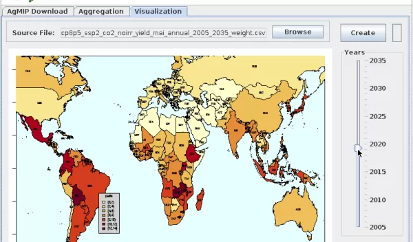
In its first year, the GABBs team worked with scientists from the Agricultural Model Intercomparison Project (AgMIP) and the GEOSHARE project to create a tool that models the impacts of climate change on historical and future crop yields.
While the datasets on which the tool is based are freely available, the software skills required to make the data usable are a barrier to individuals who want to explore their own country, region or locale. The AgMIP tool manages the process for them, facilitating the use of important information in climate change assessments that can be used to project potentially devastating reductions in food crops in certain parts of the world, among other things.
"This example demonstrates the potential of the GABBs project for making geospatial modeling and data visualization much more broadly available beyond the traditional geospatial community," says Carol Song, a senior computational scientist at Purdue University and principal investigator on the project. "The tool truly improves the usability of the dataset, allowing experienced users to get results faster, and allowing the non-experts to explore. The data archive creators embraced the tool enthusiastically because it helps broaden and democratize the use of the data."
The AgMIP tool is a test case for the ultimate aim of the GABBs project, which is to build easy-to-use software for working with and integrating a variety of types of geospatial data, and a central repository on the Web for accessing and using them.
Robert Chadduck, a program director at NSF who oversees the award, said, "The GABBs project's developments--including its Web-based 'building block' system that advances geospatial data hosting, processing, analysis and sharing--superbly embraces and advances NSF's data strategy to make research data useful to society through cyberinfrastructure."
