NEON: Opening doors with open data
2023 is the Year of Open Science, but NSF's National Ecological Observatory Network (NEON) has been providing open data to move science and education forward for the next 30 years
From soil samples to measurements taken by airplanes flying overhead, the U.S. National Science Foundation's National Ecological Observatory Network (NEON) delivers hundreds of data products free and open to all. Those data are powering research and transforming the field of ecology, expanding both how research can be conducted and who can conduct it.
A telescope trained on Earth
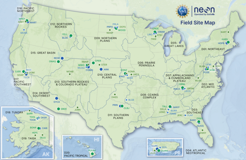
Historically, ecological research was conducted at one site or another, limiting the ability to draw conclusions about how findings might hold in other locations. NEON changed that by offering a continental-scale view with standardized data collected at 81 field sites across the United States, taking the same measurements in a variety of ecosystems from forests to grasslands and streams to lakes. Like a "telescope trained on Earth," NEON provides a view at an unprecedented scale.
Through measurements taken by automated instruments, field sampling and airborne remote sensing, NEON offers 182 different data products, including biological, atmospheric, hydrologic and geographic measurements and observations. Together, the amount of data created each year is greater than 400 terabytes — and all of it is freely accessible and open.
"From its very inception, NEON was designed to be open access, enabling scientists, educators, planners and decision makers to understand, map and predict how ecosystems change over time," said Paula Mabee, NEON chief scientist and observatory director.
Conceived in 2000 by members of the ecological sciences community, construction on NEON began in 2011 and was completed in 2019, entering operations that same year. The network is designed to collect measurements for 30 years, providing a three-decade view of ecological change at the continental scale.
Shining a light below the ground
One area of ecology where NEON is having an impact is soil science. The soil we tread on each day impacts our climate, food and water, and yet we don't often think of it as more than dirt. New data provided by NEON helps show just how much goes on within soil and is uprooting conventional wisdom on what helps soil store carbon.
Researchers have been studying how soils form and build up organic matter for centuries, but with data from NEON, scientists are able to get a new look at carbon cycling. Looking at 400 soil core samples from 34 sites, researchers at Oregon State University, along with collaborators at Virginia Tech, Michigan Technological University, the University of Colorado and the Pacific Northwest National Laboratory, found that soil moisture levels — not temperature or mineral content — regulate how well soil can store carbon.
"As the climate gets warmer and drier, we might see changes in how much carbon soil can store and how much is lost to the atmosphere," said Charlotte Roehm, the program director in NSF's Division of Biological Infrastructure who oversees the NEON program. "Understanding how the carbon cycle within soil works is key to understanding how environmental change is impacting that cycle."
Novel uses of airborne measurements
NEON's impact doesn't stop at the top of the soil. High above the ground, Airborne Observation Platform (AOP), a synergistic collection of Earth observation instruments installed into a light aircraft, collect high-resolution remote sensing data at low altitude. Those measurements are enabling new scales of ecological research.
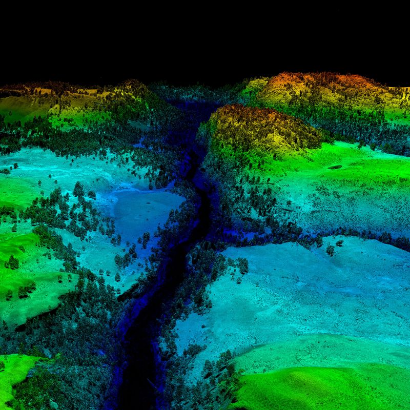
The AOP's lidar system maps the terrain, canopy structure and coverage of a site, allowing researchers to create detailed 3D maps of the land surface that can be compared year-to-year. A high-resolution RGB camera takes photos at 24 frames per second that can be combined to provide a complete picture of the site and the surrounding area. The imaging spectrometer, designed and built by NASA's Jet Propulsion Laboratory, measures light energy reflected from the ground, allowing for studies of leaf structure and plant biodiversity.
Highlighting the openness of NEON data, researchers in Canada working with measurements from the AOP's imaging spectrometer showed that "changes in plant species composition and diversity can be effectively and reliably assessed with imaging spectroscopy across terrestrial ecosystems at the beta-diversity scale — the spatial scale of space-borne missions — paving the way for close-to-real-time biodiversity monitoring at the planetary level."
"Remote imaging using light at the local, regional or global scale has huge potential to understand how plants are responding to environmental change in real time," said Allen Moore, director for NSF's Division of Environmental Biology.
Changing the face of ecology
In addition to advancing science, NEON is also increasing diversity within STEM fields. Teachers and educators can use NEON data and code packages to teach ecology and computer science to students who may not have had interactions with those fields otherwise, including those in urban areas, at under-resourced schools and those from backgrounds underrepresented in STEM.
In addition to organic uptake of NEON resources to engage diverse communities, NEON also runs an Ambassador Program designed to empower and connect a cohort of researchers and educators who add to NEON's engagement around diversity.